Live camera
Yodo and Uji Rivers live camera — Osaka / Kyoto
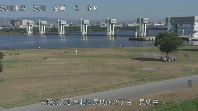
The main channel carrying Lake Biwa's water to Osaka Bay. Wide enough that the far bank and its buildings fit in frame.
 Sample October 2026
What you are looking at
Water leaving Lake Biwa takes the name Uji, passes under the hills, picks up the Katsura and the Kizu at Oyamazaki and heads for Osaka Bay. This feed shows points along that main stem in turn.
The thing to watch is the width itself. In the lower reaches the far bank and the townscape behind it fit inside the frame, so it is easy to see how far the surface spreads when the level rises. The low flood plain visible on an ordinary day is the first thing to go under.
The basin of this river system covers 8,240 square kilometres. Of that, the Lake Biwa catchment is 3,848 square kilometres, or 46.7 per cent — close to half the whole thing. The rest is the Kizu at 1,596 square kilometres or 19.4 per cent, the Katsura at 1,100 or 13.3 per cent, the Uji at 506, and the Ina at 383.
Counting up from the mouth, the Yodogawa weir sits at about 10 kilometres, the Amagase dam at about 54, and the Setagawa weir at about 70. Half the water coming from a lake, and the ability to set the discharge at a weir, are what give this river its character. Each of the two rivers it joins has its own narrow valley: the Katsura is squeezed at the Hozu gorge, the Kizu at the Iwakura gorge. At Kema in Osaka the old Yodo branches off.
By season it moves most at the close of the rainy season and through the typhoon months. But the flow here is set at weirs, so on some days how much fell and how far the level rises do not line up. In rough weather the dark and the drops on the lens make it hard to read. Let the local authority's announcements decide whether you leave. Within the one feed, the points along each reach take turns.
About this camera
| Place | Osaka / Kyoto |
| Format | Live video, rotating |
| Time zone | Asia/Tokyo (UTC+9) |
| Category | River |
| Operator | MLIT river live streams |
| Terms of use | Government Standard Terms 2.0 |
The operator's own page
The footage belongs to each agency. This site is an unofficial guide, and each sample frame was copied once per camera under that agency's terms of use.