Live camera
Eryanping trail live camera — Alishan, Chiayi
A footpath climbing through tea terraces. It faces west, so the hour when the sun drops into the sea of cloud is the one to watch.
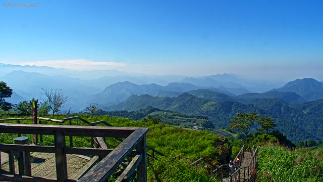 Sample October 2026
What you are looking at
In the sample frame there is a wooden deck and railing in the foreground, and beyond it ridge after ridge recedes into haze. Terraced fields and grass spread across the slope to the right, and at the bottom right of the picture someone is walking down a flight of wooden steps. The sky is a cloudless blue.
The Eryanping Trail is on the Alishan Highway, Provincial Highway 18, at around the 52.9 km mark, at Xiding in Fanlu Township, Chiayi County. The elevation is roughly 1,200 to 1,400 metres. From the viewing platform at the entrance you look down on the Chianan Plain and the Bazhang River, and this is held to be the first place where cloud seas can be met as you climb the Alishan Highway. People gather here on winter evenings.
Taiwan is only one hour behind Japan, so six in the evening in Japan is five in the evening in Taiwan. Almost no arithmetic is needed to open it as the sun drops.
The middle stretch of the trail is tea fields. The Xiding tea district lies between the valley of the Zengwen River and the valley of the Bazhang River; oolong and jinxuan do well here, and Alishan Fo Shou tea is made here too. The stone walls holding up the terraces are built from stones dug out while the land was being cleared. The name Xiding — "gap top" — comes from the gap between Mount Xiding and Mount Eryanping. The trail itself was worked on from September 2021, with about 570 metres of sleeper steps, about 300 metres of boardwalk and six pavilions and platforms rebuilt, and it reopened in 2022.
The trail opens to the west, so the hour held to be worth watching is the evening, when the sun goes down into the sea of cloud. Whether that cloud forms differs from day to day, though, and once the valleys fill the layered ridges disappear. On a hazy day you cannot count the far ridges the way the sample frame does.
About this camera
| Place | Alishan, Chiayi |
| Format | Live video |
| Time zone | Asia/Taipei (UTC+8) |
| Category | Nature |
| Operator | Alishan National Scenic Area |
| Terms of use | Taiwan open government data |
The operator's own page
The footage belongs to each agency. This site is an unofficial guide, and each sample frame was copied once per camera under that agency's terms of use.
Cameras nearby
- Taiping Suspension BridgeMeishan, ChiayiLive video
- LijiaAlishan, ChiayiLive video
- Shengli tea farmAlishan, ChiayiLive video
- Niupuzai meadowFanlu, ChiayiLive video
- Hushanyan daylily fieldsHuatan, ChanghuaLive video
- Emei Lake and the Great Maitreya, ShitoushanEmei, HsinchuLive video
- Changhua plain from BaguashanBaguashan, ChanghuaLive video
- Emei Lake and Dapu Reservoir, ShitoushanEmei, HsinchuLive video