Live camera
Higashi-Harima coast live camera — Akashi–Kakogawa, Hyogo
A sandy shore on the Seto Inland Sea. This camera shows coast rather than river, so wave height and tide are what to watch.
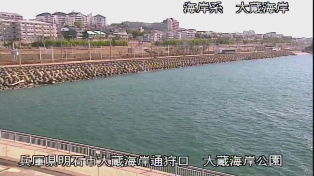 Sample October 2026
What you are looking at
This is the one feed here that shows the sea rather than a river. The coast runs some 26 kilometres, from the Sakai river at Shioya in Tarumi, Kobe, through Akashi, to the Kise river at Harima in Kako. The feed shows points along it in turn.
The thing to watch is how much width of sand is left. On a day of high waves the waterline disappears and the water comes right up to the revetment. The difference from a day at low tide shows directly in the picture, so it helps to look at the same place at different hours.
This coast eroded badly and suffered heavily in typhoons. Work therefore began in the 1961 financial year as a national project, carried out on behalf of Hyogo Prefecture. The erosion came from high typhoon waves, from the extraction of sea gravel that continued into the middle of the 1950s, and from the fast tidal current in the Akashi Strait. Off Matsue in Akashi the waterline retreated by more than a hundred metres over sixty-three years. Since sand began to be added by nourishment, no further retreat has been seen.
About 19 kilometres have been worked in four sections: Harima, West Akashi, East Akashi and Tarumi. The gradient of the sea bed changes at the Akashi river, so the western side combines revetment with nourishment and the eastern side combines detached breakwaters with nourishment. The West Akashi section, the seven kilometres or so from Eigashima port to Hayashizaki fishing port, was completed on 31 March 2020, and from 1 April the general coastal structures passed to Hyogo Prefecture and those inside the fishing port area to the city of Akashi. In 2018, typhoons Cimaron and Jebi pushed tide levels at Akashi and Kobe past their previous records, yet no major damage occurred where the work had been done.
Waves are highest during the typhoons of August and September. The rougher the day, the darker the picture, and spray on the lens blurs it. Please stay away from the shore when a storm surge or high wave warning is in force. The feed rotates between points.
About this camera
| Place | Akashi–Kakogawa, Hyogo |
| Format | Live video, rotating |
| Time zone | Asia/Tokyo (UTC+9) |
| Category | Sea |
| Operator | MLIT river live streams |
| Terms of use | Government Standard Terms 2.0 |
The operator's own page
The footage belongs to each agency. This site is an unofficial guide, and each sample frame was copied once per camera under that agency's terms of use.
Cameras nearby
- Maruyama and Izushi RiversToyooka, HyogoLive video, rotating
- Kako and Manganji RiversKakogawa, HyogoLive video, rotating
- Ibo and Hayashida RiversHimeji, HyogoLive video, rotating
- Ina and Mo RiversHyogo / OsakaLive video, rotating